
Trace a Spring Valley Street by Address
A Spring Valley street directory search begins with the situs address, which is the physical parcel location. Normalize abbreviations such as St or Street, preserve W or E prefixes, and include any unit number. The Clark County Assessor returns the current parcel card, while OpenWeb provides the mapped parcel and nearby polygons. The map is useful for walking one visible street segment, but Clark County does not publish a single automated whole-street result mode on the public Assessor page.
Spring Valley, the Spring Valley TAB area, a Spring Valley parcel, and a Spring Valley postal address can use related but distinct labels. Preserve the county jurisdiction beside each street result.
- Search the address in the Clark County Assessor and save the APN, situs, mailing address, subdivision, lot and block, and recorded-document number.
- Open the APN in Clark County OpenWeb, confirm the Spring Valley jurisdiction, and click neighboring parcels only when a parcel-by-parcel comparison is needed.
- Use the APN, legal description, document number, and owner name variants in the Recorder index to identify recorded instruments and prior parties.
- Check a public voter file or office procedure only within the disclosure limits of NRS 293.440 and NRS 293.558.
- For a past year, consult the verified criss-cross and library sources, then compare the address with the correct publication date.
Each step establishes a different fact. The Assessor shows a current tax-roll connection. The Recorder shows a document party and date. A directory can show an address entry in its printed year.
Spring Valley Street Directory Search Fields
The Clark County Assessor real-property search is the first official tool for a street query. It provides address, owner-name, parcel-number, subdivision-name, subdivision-owner, parcel type or book/page, parcel-number tree, and parcel-map routes. An address search is structured around the street number, name, type, direction, and unit patterns used in county forms. The display may hyphenate an 11-digit APN even when another map or search box needs digits without punctuation.
| Field or route | Street-directory use | Result to keep |
|---|---|---|
| Address | Locate a site parcel | Situs, unit, APN, jurisdiction |
| Parcel Number | Reopen an exact county parcel | All 11 APN digits |
| Subdivision Name | Resolve a development or common element | Subdivision and plat reference |
| Book & Page | Connect a plat reference | Lot, block, and legal description |
| Parcel Number Tree | Review related parcel hierarchy | Successor or related APNs |
The county’s property-search screen shows these choices before a street directory result is selected.
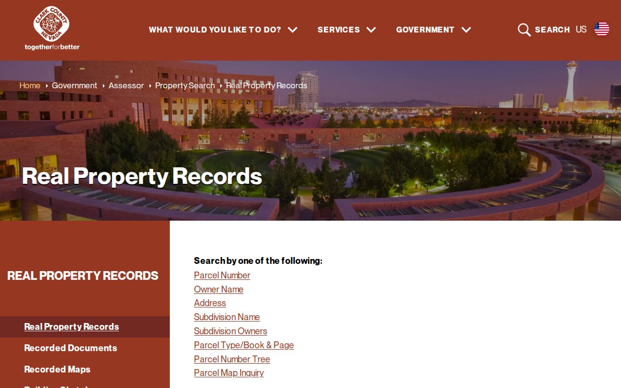
Copy the returned APN exactly. It is more stable than an abbreviated street name and lets the next search use the same parcel. A Spring Valley address note should keep the full APN with its street and unit fields.
Spring Valley Streets in OpenWeb
Clark County OpenWeb adds the map layer to a street directory search. Its parcel popup can show the APN, owner, site address, jurisdiction, sale date and price, lot size, construction year, recorded-document number, planned land use, zoning, subdivision, book and page, lot and block, township-range-section, tax district, census tract, flood information, and links to other county tools. A Spring Valley parcel can display a county jurisdiction label alongside a Las Vegas mailing label.
To examine a street segment, zoom to the target parcel and click the visible polygons one at a time. Save a separate row for each APN. Do not treat the map as a survey, and do not call nearby polygons a shared household or social group. For a condominium, the same street address can represent many unit parcels; use the unit, lot, and legal description before drawing any ownership conclusion.
Note: The OpenWeb popup can shorten an owner or address line, so use the linked Assessor card when the full mailing and situs fields matter. Spring Valley map work benefits from checking both county views.
Spring Valley Street Directory Address Labels
A by-address search is more reliable when each address label is kept in its own column. Spring Valley is an unincorporated Clark County town and CDP. The county map and parcel card determine the civic record path, while the postal city is a delivery label. ZIP boundaries also cross planning areas and do not establish that a property is inside the City of Las Vegas or Spring Valley.
- APN
- The 11-digit Assessor Parcel Number that links the parcel card, map, and Recorder research.
- Situs address
- The physical parcel location used by Assessor, GIS, permits, and maps.
- Mailing address
- The tax correspondence address associated with the owner or contact. It can be elsewhere.
- Plat
- A recorded map that identifies a subdivision, lot, block, and related legal layout.
- Criss-cross directory
- A dated historical directory organized by street address rather than alphabetically by name.
Keep the postal city, ZIP, town or CDP label, APN, and legal description together. That note resolves many cases where an old directory says Las Vegas while a modern parcel says CC Spring Valley.
Spring Valley Street Directory Record Sets
Address-keyed records work as an evidence ladder. Parcel geometry establishes the mapped location. The Assessor supplies the current tax-roll owner and two address fields. The Recorder supplies recorded parties and instrument history. Permit material can document an application or work event. A directory or newspaper may place a person at an address on a historical date. The sequence keeps one record type from being used to claim more than it actually proves.
| Address record | Clark County keeper | Street-directory value | Access route |
|---|---|---|---|
| Assessor parcel | Assessor | Owner, mailing and situs, APN, sale, structure | Free real-property search |
| GIS parcel | GIS / OpenWeb | Map geometry, jurisdiction, zoning, links | Free interactive map |
| Recorded instruments | Recorder | Principal parties, date, document number, legal description | Online summary, counter, or copy order |
| Permit or code file | Building, Fire, Public Works | Address or APN event, application, documents | Public search; some plans office-only |
| Voter list | Elections | Public registration fields, subject to withholding | Statutory list and county data channels |
| Criss-cross directory | Library or archive | Dated printed address entry | Collection access varies by year |
The parcel number is the bridge across the current county systems. Street spelling is still useful, but it can vary in documents, postal labeling, historic indexes, and unit-based properties. For Spring Valley records, that bridge keeps a parcel chain from drifting to a similar Las Vegas address.
Spring Valley Street Directory Deed Trail
Use the Assessor’s recorded-document number and legal description to enter the Clark County Recorder AcclaimWeb index. Its modes include Simple Search, Name, Parcel, Instrument, Document Type, Book/Page, Record Date, Total Value, and Legal Description. Search the current owner or grantee, then identify the seller or grantor in the latest conveyance. Repeat the name and legal-description search for the earlier deed while testing the same lot, block, subdivision, or APN.
The Recorder indexes principal parties and recording year, not every person named inside a document. Search APN and spelling variants together. Online results are summaries; original documents are viewed in the Records Research area or ordered from the Recorder. The county says recorded-document images on parcel pages are available from September 15, 1999 forward, so older deeds need the office, older books, or microfilm route.
The Recorder’s document-type and date screen is the official entry for an address record chain.
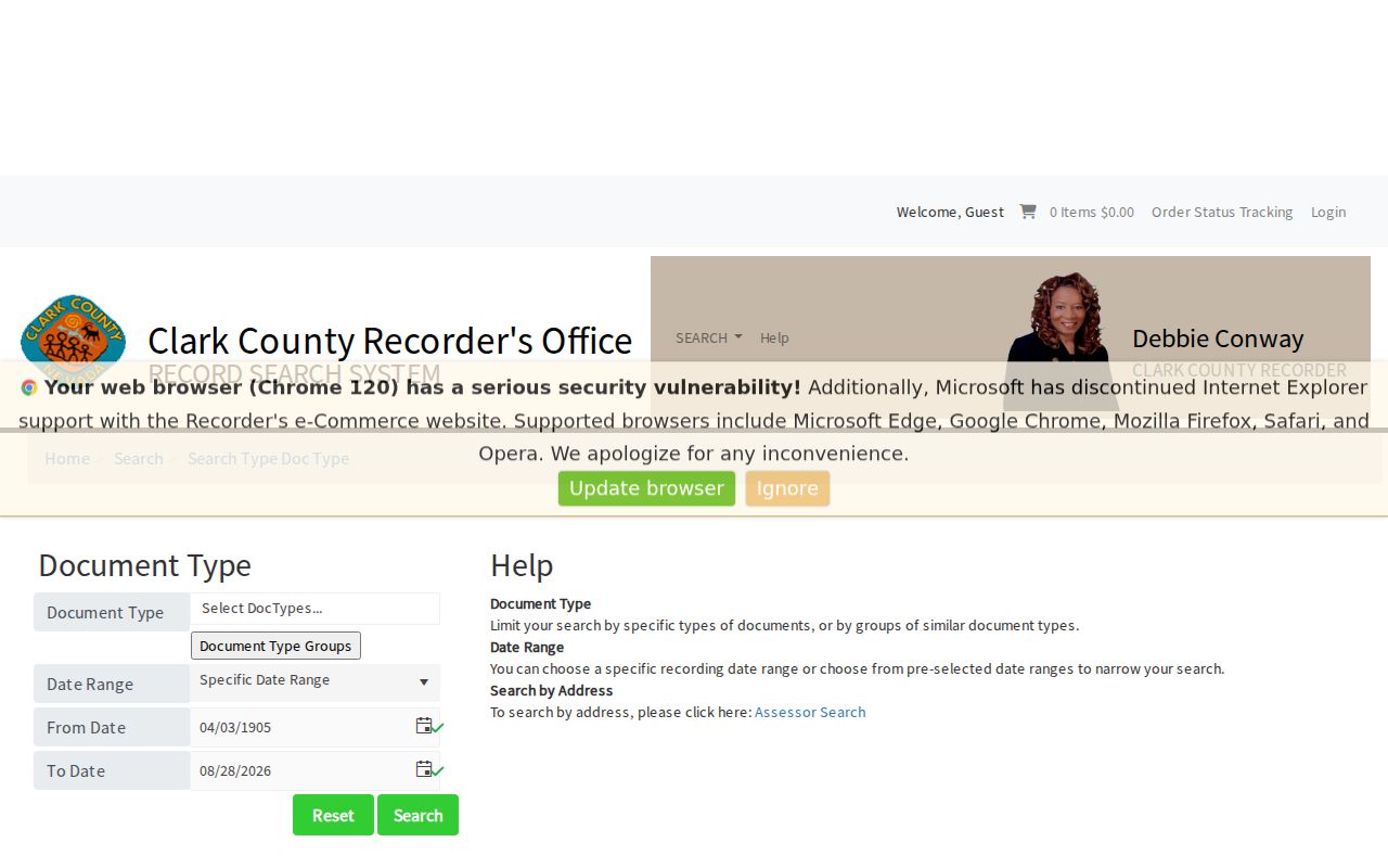
A deed identifies a recorded conveyance, not every person connected with the property at the time of recording. A Spring Valley deed trail stays reliable only when its legal description matches the parcel.
Spring Valley Street Permit Evidence
Clark County’s address tools add an event layer to a street directory search. The Building and Fire document search accepts an application choice for Building Department, BDFP Code Enforcement, or Fire Prevention, then permits Record Number, Parcel Number, Location, and document-type searches. Development Review accepts an application number, address, or cross streets. Citizen Access also offers public general, address, licensed-professional, record-information, trade-name, and contact searches, with an optional date range that defaults to the last five years.
A permit may identify an owner, applicant, contractor, project, or work date. It is evidence of work or an application at the address, not a statement of current residence. Copyright-protected plans can be office-only, and older development files may not expose every field online. Spring Valley permit records should remain tied to the location or APN searched.
Spring Valley Street Directory History
Historical street work uses a limited but valuable set of regional collections. Verified Luskey Las Vegas Criss-Cross editions exist for 1956, 1957, 1959, 1966, and 1967 at the Nevada State Museum. UNLV’s Regional History Files list a 1969 Las Vegas city-directory file, and the Polk Las Vegas and vicinity map and street index covers 1957 through 1961. Spring Valley’s present footprint developed later in many places, so an early address can appear under Las Vegas, a tract name, or not at all.
Read an address section first, then use an alphabetical section to test a name form. Compare the street with historic plats, county street maps, and the legal description before assuming a changed number or name. No verified Spring Valley renumbering year was located. For the archival holdings themselves, the Spring Valley city directory page keeps the collection details separate from this current address workflow.
UNLV’s four microfilm reels for Nevada Territory and United States city directories cover 1861 through 1882, while Cahlan holds phonebooks, newspapers, maps, and yearbooks by appointment. Those collections can support a date-specific address search, but they should not be treated as a complete street directory for a modern subdivision. Match the printed geography and year to the parcel trail before using an entry as historical evidence.
Spring Valley Street Records by APN
APN and legal-description research matters most when a street record is ambiguous. A subdivision can change from a parent tract to a later phase or unit, and a parcel-number tree can reveal related APNs. The Assessor road-document route also uses a parcel number or recorded document number because a road right-of-way may not have an ordinary situs address. For a common-element parcel, a subdivision-owner search can reveal an association or development record without identifying the people associated with nearby units.
When a result is missing, compare the unit, street direction, old plat, adjacent parcel, and lot or block. Record the exact source label and date. That process is more reliable than treating a partial street-name match as a complete record. A Spring Valley APN can also expose a later split or related parcel.
Spring Valley Street Directory Limits
A Spring Valley street directory cannot show every person at an address. DMV address data is restricted under the federal Driver’s Privacy Protection Act. Utility customer records are not an open county dataset. A parcel card can identify a current owner or mailing contact, not each occupant. A Recorder index is limited to principal document parties. Voter address and phone information may be withheld, and Confidential Address Program protections apply to eligible people. Court, permit, business, and obituary records also require a narrow reading of what the record actually documents.
Lawful use. Use Spring Valley address records for personal, civic, genealogical, estate, reconnection, and safety research. Do not use an address result to stalk, harass, intimidate, or harm another person.
Commercial neighbor tools may infer associations from old public data. They are not substitutes for the Assessor, Recorder, Elections, or library record that identifies the source, date, and limits.
Spring Valley Street Search Fallbacks
If a street query fails, use OpenWeb map navigation and record a manual sequence of visible APNs for the segment. Capture the cross streets, subdivision, ZIP, and jurisdiction, then inspect individual parcels. The county can supply an existing address-indexed permit or development report through the appropriate procedure, but it need not build a new streetwide residents list. For an older address, take the APN, name variants, date range, and legal description to the Recorder research area, a library, or an archive.
Libraries can help with a historical street section, but coverage depends on year, geography, and whether the development existed. Where no record is found, check alternate street names, historic plats, a neighboring parcel, and the legal description before concluding that the record is absent.
The county Spring Valley TAB map and GIS ZIP-boundary layer are useful final checks when a result uses a Las Vegas postal label or lies near a planning-area edge. A Spring Valley property and the Spring Valley TAB boundary should be noted separately.